1601.2012

Between September 10 and 22, 2011, a Bulgarian exploratory expedition visited the Khane Valley in the Karakoram, Pakistan, with the goal to investigate and assess the possibilities for new big-wall routes and ascents on so far unclimbed summits. Our team included Nikolay Petkov, Doychin Boyanov and Mihail Mihaylov.
REPORT - KHANE VALLEY, TAGAS GROUP, KARAKORUM, PAKISTAN
The Khane Valley was chosen as a result of a long and detailed preliminary investigation of existing data about the Karakoram Mountains, more specially the Masherbrum Range – the K6, Chogolisa, Honboro and Tagas Groups. Our interest in these mountain ranges dates from 2005 and 2006 when D. Boyanov and N. Petkov crossed the valleys in the north-south direction while coming down from Gondokhoro Pass and was further aroused in 2009 on the way back from the Gasherbrum I expedition. It was then when we photographed some of the summits having only initial guesses about their position and state of exploration. As the Charakusa and Nangmah Valleys have been well studied and seen many climbing expeditions, the team focused their attention to their southern neighbor: the Khane Valley. According to existing information, it looked like a blank spot on the map – unnamed summits and no data about any alpine ascents. For lack of time and financing, we concentrated all our efforts in this valley with the hope to find summits and walls that could be of some interest for future first ascents. Despite the risk of disappointment, what we saw completely met our expectations and the results were impressive. With this report, we’d like to bring these results to the knowledge of the whole mountaineering and climbing community and give some information and photos to potential mapmakers of the region.
In the course of this investigation, we used information and maps by Jerzy Wala; other sources were Google Earth, the 2005 Annual Book of the Korean Students’ Alpine Federation as well as verbal reports from inhabitants of Khane Village and locals that took part in the 3rd Korean expeditions in the valley.
On September 11, 2011, after a two-day walk from Khane Village, the team built a base camp at 4650 m on the right-hand (north) moraine of the Khane Glacier; called “the Bulgarian Base Camp”.
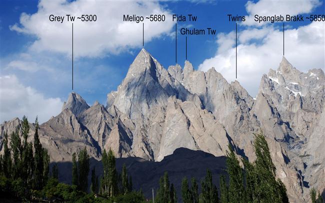
We observed, photographed and measured the summits in the upper part of the valley: Hidden Tower (~5830 m), Agil (~5680 m), Tangra (~5620 m), Rila (~5600 m), Sofia (~5550 m), Meligo (~5680 m), Gray Tower (~5300 m), etc.
The heights determined by us were measured with a GPS Garmin with an average horizontal accuracy of 6 to 8 m, corresponding to a vertical accuracy of about 20 meters. All other height figures, marked with the tilde sign (~), are tentative, taken from the Google Earth model for this region.
The Khane Valley. Historical data
For many years, the Khane Valley has remained in the shadow of the neighboring Nangmah and Charakusa Valleys, immediately to the north and parallel to it. The main reason is Charakusa and Nangmah’s greater potential for first ascents on the walls of unclimbed peaks. That is why, in the 1990s and 2000s, this was a region of great interest for climbers due to its high quality granite. Currently, the main summits and walls in these two valleys have all been climbed.
To date, the Khane Valley has only been of any importance for the inhabitants of the village with the same name, providing pasture for their livestock. That is why most summits in the region were unnamed. The only ones having local names were the ones visible from the villages along the Hushe River, the Nangmah Valley and the pastures along the Khane River up to around 4300 m above sea level.
According to locals from Khane Village, the first foreigner to visit the valley, in 2001, was Korean; he came two more times and made two unsuccessful attempts to climb, most probably, the west wall of Agil Summit. The Koreans set camp at 4450 m and during their second visit opened a climbing route on a 250-meter high rocky outcrop nearby – probably reaching the very top of this satellite arête. Actually, this is the first route to be made here, yet too insignificant with all those big walls at the background, closing the valley in all direction. There are no data available about attempts on other summits or any exploration of climbing and mountaineering conditions.
According to the locals, another visit was made by an American, who came for a trekking after an expedition to Ogre Peak. She reached the foot of Great Tower using the approach by the big grassy terrace (First Terrace) along the side valley between Rila and Tangra Peaks to the east and Sofia Peak to the west.
Other ascents before 2011 were made starting from the Nangmah Valley on Black Tower (Sarigo) and Singu Chatpa (also called Singu Charpa and Great Tower). There is a small but very beautiful pointed peak towering over Khane Village, called Nauari Brakk (~3250 m); this was first climbed in 2009 by the local villagers Ali Mehmed and his son, Ruhal Ali. All other summits from both main ridges enclosing the valley are currently unclimbed.
The Khane Valley. Geographic description
The Khane Valley is perpendicular to the Hushe River in Karakoram’s Masherbrum Range. To the north, it is separated from the Nangmah Valley by a serrated rocky ridge. Another rocky barrier delimits its southern edge, separating it from the small valley above Haldi Village (also Halde). To the east, where the main ridge makes an almost right-angle curve, is the upper part of the Tagas Valley. The ridge in the northeastern part of the valley borders on the upper side of the Lachit Valley and Glacier. The highest part of the Khane Valley is orientated in the north-south direction and the main part in the east-west-northwest direction. The right-hand (north) and left-hand (south) sides of the Khane Glacier and River are delimited by two main ridges. To the north, the right-hand one slopes down to the Nangmah Valley. Its main peaks are Black Tower (Sarigo) and Great Tower (Singu Chatpa).
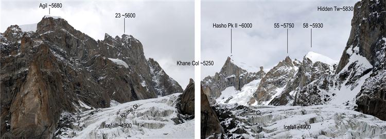
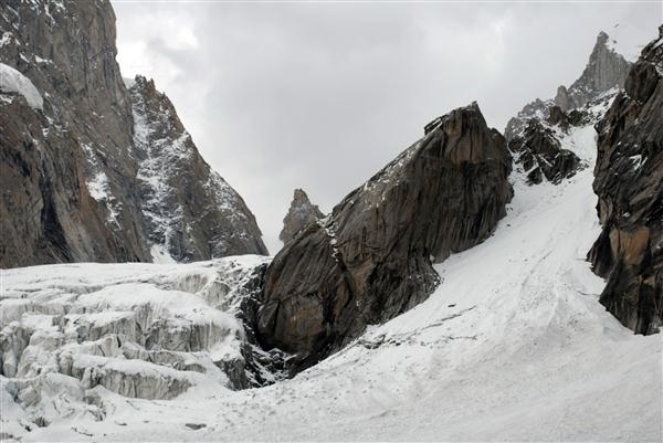
The Khane Glacier flows south through the Khane Col (~5250 m). At first, it moves in the north-south direction, then, after an icefall at 4900 m, it abruptly turns west. At 4400 m, the glacier’s snout gives rise of the Khane River, flowing northwest. This is the place we named Second Terrace, where the Korean camp was situated. After a steep drop, the river forms a waterfall and flows through a wide grassy plain (First Terrace) used for pastures.
The main peaks situated on the left-hand side of the glacier above Khane Col are Hasho II (~6000 m), Peak 58 (~5930), Hidden Tower (or Peak 59, ~5830), Khanlim (Peak 60) and the Twins. On the right-hand side of the glacier are Peak 23 and Agil (~5680). At the base of the Twins’ north wall, the Khane Glacier abruptly turns west along the north slopes of the southern ridge.
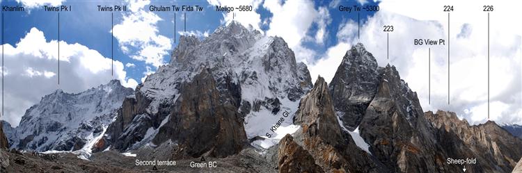
Immediately before sloping down to the Hushe Valley, the left-hand (southern) ridge has two main peaks: Meligo (~5680 m) and Grey Tower (~5300 m). Meligo Peak is separated from the Twins to the east by a saddle that can be reached by an iced gully between the Twins and the Saws Ridge. Seen from the north (from Khane), Meligo is characteristic with two big rocky arêtes, named the Ghulam and Fida Towers (~5200 m), which rise from the main ridge coming from the east. To the west, it is connected to Gray Tower. Down to 4400 m, Meligo’s northern slope is covered with the South Khane Glacier. This can be crossed and, after a small saddle and crossing a steep gully, the saddle between Meligo and Gray Tower is reached at 5000 m. After Gray Tower, the ridge (~4800 m high) gradually slopes down to the valley at Khane Village (2800 m).
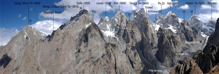
The right-hand main ridge begins from Khane Pass. It is directed from the east to the northwest. Starting from Khane Pass, it includes Peak 23 (~5600 m), the Trident (Peak 26, ~5550 m), the Thumb (Peak 31, ~5480), Peak 32, Tangra Tower (Peak 33, ~5620 m), Rila Peak (Peak 36, ~5600 m), Levski Peak (Peak 38, ~5620 m), Singu Chatpa/Great Tower (Peak 44, ~5910 m), Gamgar Brakk (an arête between the two main summits), Black Tower/Sarigo (Peak 50, ~5600 m) and, immediately above Khane Village, Nauari Brakk (Peak 52, ~3250 m).
Agil (Peak 24, ~5680 m) is a prominent summit situated south of the main ridge, on a secondary ridge starting from Peak 23 and sloping down to the middle of the valley where the glacier forms a right angle.
The other prominent summit visible to the north from the First Terrace is Sofia (Peak 39, ~5550 m). It is situated on a side ridge, starting from the main one at Singu Chatpa and going south.
The North Cirque (5100 m) is at the bottom of the valley flanked by Agil Peak to the east, Tangra Peak to the west and the Trident and Khane Col II to the north. Starting from the cirque, the North Khane Glacier flows to the south, perpendicularly to the main Khane Glacier. Its terminus gives rise of a big stream and valley descending all the way down to the glacial plain named Second Terrace.
Another big cirque and a relatively easily accessible valley are formed between Singu Chatpa and Sofia Peak to the west and Levski and Rila Peaks to the east. This valley goes down to the glacial plain named First Terrace.
Narrow and closed but well-shaped, a third valley is situated between Black Tower, Singu Chatpa and Sofia Peaks. It goes down to the lower part of the main valley, close to the beginning of the abandoned artificial channel.
Apart from the peaks forming the high ridges, other places of interest from the climber’s point of view are the rocky faces of the towers in the lower zone, immediately above the valley’s bottom. These are prominent rocky needles and towers with 300 to 400-meter high-quality granite walls. These satellite peaks are more characteristic for the northern slopes, which means that they have predominantly south, west and east faces, with no snow or ice on them. They are suitable for multi-pitch rock-climbing routes.
* The right-hand and left-hand directions are determined as observed whilst facing downstream.
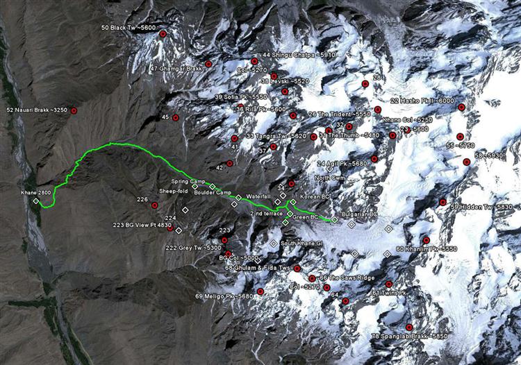
Map based on the image in Google Earth
The Khane Valley. Access
A three-hour SUV drive along the valleys of the Indus and Shyok Rivers leads from Skardu, the administrative capital of the Pakistan’s Baltistan Province, to the town of Khaplu. Up to this point, there is an asphalt road in a pretty good state. From Khaplu, take the wire-rope bridge across the Shyok River to the north, towards the villages of Machulu and Khane. This is the road of Hushe. About 1:30 hours from Khaplu (dirt road) the village of Khane is reached, situated on the left bank of the Hushe River, at 2800 m. This village is relatively unknown to foreign visitors. The locals grow crops and breed animals, mainly goats, sheep and yaks.
For the time being, there is no special permit needed to visit Khane and the neighboring Nangmah Valley. By contrast, to visit other valleys in the region, as the Charakusa Valley, you need a trekking permit. As the summits don’t surpass 6500 m, no permit is needed for them either.
On the map, there are many other valleys visible to the south and east of Khane – the Haldi, Tagas, Tsino and Lachit Valleys – but all of them a closed to foreign visitors (except the first one may be), and this applies to all ramifications of the Saltoro and Kondus Valleys all the way back to the Siachen Glacier, the demarcation line with India. The military checkpoint and barrier are in the village of Haldi.
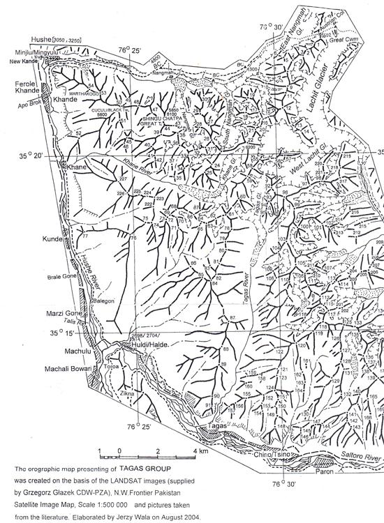
Map of the Tagas Group by Jerzy Wala
There is no special camping place in Khane Village, so we stayed with the locals – at the house of a member in different expeditions, as porter and guide. Great hospitality, for a certain payment of course.
Khane Village is the starting point of the trek, going east on the steep sandy slope of the river’s left bank. After reaching an irrigation channel* cut into the slope, the path follows this horizontally towards the Khane River. After a 5-hour’s walk, you reach the big grassy plain (First Terrace) at 4000 m. Here, the first camp is set up in the vicinity of the livestock pens (a camping tax is collected). From here on, there are excellent places to set camp for climbing in the valley. Starting from the green terrace, the path initially crosses flat fields on both sides of the Khane River until it reaches the far end of the terrace (it is advisable to use the northern river bank, i.e. the left-hand one when going upstream). A 450-meter ascent leads to the Korean Base Camp at the bottom of the valley coming down from the North Cirque. The Bulgarian Camp is reached in one hour going east, upstream the main Khane Glacier. It is situated on the large sandy flats to the right (or to the left when going up) of the glacial moraine at 4650 m. This is the last good place with hard soil and water. From the Bulgarian Camp, the Khane Icefall is reached in 1:30 hours. This is also the way to reach the Hidden Tower wall. The icefall can be climbed in its left-hand side. An early start is advisable because of the two huge seracs hanging from the western slopes of Khanlim Peak (Peak 60).
* The channel was built in the early 2000s with European funding. After the last earthquakes in Pakistan it has been damaged, potentially irreversibly, and is unusable at the moment. However, the path along it is well kept as a good access route to enter the valley at relatively high altitude (~3200 m).
In the course of the expedition we took photographs of most walls and peaks as well of some panoramic pictures.
Panoramic view of the Khane Valley – northern part
Panoramic view of the Khane Valley – southern part
Panoramic view of the Khane Valley – southern part from the southwest
Panoramic view of the Khane Valley – upper part
Khane Col, ~5250 m, the beginning of the Khane glacier. On the other side are the South Nangmah Glacier and the Nangmah Valley itself
The names given by the Bulgarian expedition
When naming the peaks, we have taken into consideration, at the first place, existing local names, and then the ones given by the Korean expedition. For all others, we have used the numbering and elevations quoted on maps by Jerzy Wala. Geographic names given by the Bulgarian expedition are the following:
Summits
Hidden Tower (~ 5830 m) – Peak 59
Tangra Tower (~ 5620 m) – Peak 33
Rila Peak (~ 5600 m) – Peak 36
Sofia Peak (~ 5550 m) – Peak 39
Levski Peak (~ 5520 m) – Peak 38
The Trident (~ 5550 m) – Peak 26
The Thumb (~ 5480 m) – Peak 31
Ghulam & Fida Towers (~ 5100 m) – Peak 68
Grey Tower (~ 5300 m) – Peak 222
The Saws Ridge, Peak 66
Saddles
Khane Col (~ 5250 m) – the saddle separating the uppermost part of the Khane Valley from the Nangmah Valley.
Glaciers and cirques
North Cirque & North Khane Glacier (~ 5000 m)
South Khane Glacier (~ 4900 m)
Other places
First Terrace – a glacial plane in the valley at ~ 4000 m
Spring Camp – a place suitable for camping, with spring water, at 4000 m on the First Terrace, GPS N35.3295 E76.4312.
Boulder Camp – a place suitable for camping at 4050 m on the First Terrace between big boulders (sheltered from wind), GPS 35.3295 E76.4312.
Second Terrace – a glacial plane in the valley at ~ 4400 m, just down from the glacial terminus.
Green Camp – a place suitable for camping with flowing water just above the Second Terrace, at 4490 m, GPS 35.321974 76.450113.
Deer Lakes – the glacial lakes at ~ 4650 m
Bulgarian Base Camp – a flat place on the glacier’s side moraine at 4650 m, GPS 35.322633 76.462521.
Във втора част на статията ще бъдат описани основните върхове в долината Хане.
ACKNOWLEDGEMENTS
We express sincere thanks to all who supported the exploratory expedition. And in particular:
The Bulgarian Ministry of Sports, http://mpes.government.bg
The Bulgarian Climbing and Mountaineering Federation, http://www.bfka.org
The Bulgarian Embassy in Islamabad, http://www.mfa.bg/bg/56/
The National Sport Academy, http://www.nsa.bg/
Our partner in Pakistan, Jasmine Tours, http://www.jasminetours.com
Petar Atanasov (http://banskofilmfest.com), for connecting us with Karakoram expert Jerzy Wala
Wild Climb, http://climbnsa.com/2010/08/31/wild-climb/, – sponsor

Alpi, http://alpibg.com/, – sponsor

Participants in the expedition and authors of the report:
Nikolay Petkov, Eng. Ph.D., www.cmstory.com, www.climbingguidebg.com, http://planinetz.org/
Doychin Boyanov, Ph.D., http://www.nsa.bg/, http://www.verticalworldbg.com/
Mihail Mihaylov, Ph.D., http://www.nsa.bg/, http://planinetz.org/
October 2011, Sofia
REPORT - KHANE VALLEY, TAGAS GROUP, KARAKORUM, PAKISTAN
The Khane Valley was chosen as a result of a long and detailed preliminary investigation of existing data about the Karakoram Mountains, more specially the Masherbrum Range – the K6, Chogolisa, Honboro and Tagas Groups. Our interest in these mountain ranges dates from 2005 and 2006 when D. Boyanov and N. Petkov crossed the valleys in the north-south direction while coming down from Gondokhoro Pass and was further aroused in 2009 on the way back from the Gasherbrum I expedition. It was then when we photographed some of the summits having only initial guesses about their position and state of exploration. As the Charakusa and Nangmah Valleys have been well studied and seen many climbing expeditions, the team focused their attention to their southern neighbor: the Khane Valley. According to existing information, it looked like a blank spot on the map – unnamed summits and no data about any alpine ascents. For lack of time and financing, we concentrated all our efforts in this valley with the hope to find summits and walls that could be of some interest for future first ascents. Despite the risk of disappointment, what we saw completely met our expectations and the results were impressive. With this report, we’d like to bring these results to the knowledge of the whole mountaineering and climbing community and give some information and photos to potential mapmakers of the region.
In the course of this investigation, we used information and maps by Jerzy Wala; other sources were Google Earth, the 2005 Annual Book of the Korean Students’ Alpine Federation as well as verbal reports from inhabitants of Khane Village and locals that took part in the 3rd Korean expeditions in the valley.
On September 11, 2011, after a two-day walk from Khane Village, the team built a base camp at 4650 m on the right-hand (north) moraine of the Khane Glacier; called “the Bulgarian Base Camp”.
We observed, photographed and measured the summits in the upper part of the valley: Hidden Tower (~5830 m), Agil (~5680 m), Tangra (~5620 m), Rila (~5600 m), Sofia (~5550 m), Meligo (~5680 m), Gray Tower (~5300 m), etc.
The heights determined by us were measured with a GPS Garmin with an average horizontal accuracy of 6 to 8 m, corresponding to a vertical accuracy of about 20 meters. All other height figures, marked with the tilde sign (~), are tentative, taken from the Google Earth model for this region.
The Khane Valley. Historical data
For many years, the Khane Valley has remained in the shadow of the neighboring Nangmah and Charakusa Valleys, immediately to the north and parallel to it. The main reason is Charakusa and Nangmah’s greater potential for first ascents on the walls of unclimbed peaks. That is why, in the 1990s and 2000s, this was a region of great interest for climbers due to its high quality granite. Currently, the main summits and walls in these two valleys have all been climbed.
To date, the Khane Valley has only been of any importance for the inhabitants of the village with the same name, providing pasture for their livestock. That is why most summits in the region were unnamed. The only ones having local names were the ones visible from the villages along the Hushe River, the Nangmah Valley and the pastures along the Khane River up to around 4300 m above sea level.
According to locals from Khane Village, the first foreigner to visit the valley, in 2001, was Korean; he came two more times and made two unsuccessful attempts to climb, most probably, the west wall of Agil Summit. The Koreans set camp at 4450 m and during their second visit opened a climbing route on a 250-meter high rocky outcrop nearby – probably reaching the very top of this satellite arête. Actually, this is the first route to be made here, yet too insignificant with all those big walls at the background, closing the valley in all direction. There are no data available about attempts on other summits or any exploration of climbing and mountaineering conditions.
According to the locals, another visit was made by an American, who came for a trekking after an expedition to Ogre Peak. She reached the foot of Great Tower using the approach by the big grassy terrace (First Terrace) along the side valley between Rila and Tangra Peaks to the east and Sofia Peak to the west.
Other ascents before 2011 were made starting from the Nangmah Valley on Black Tower (Sarigo) and Singu Chatpa (also called Singu Charpa and Great Tower). There is a small but very beautiful pointed peak towering over Khane Village, called Nauari Brakk (~3250 m); this was first climbed in 2009 by the local villagers Ali Mehmed and his son, Ruhal Ali. All other summits from both main ridges enclosing the valley are currently unclimbed.
The Khane Valley. Geographic description
The Khane Valley is perpendicular to the Hushe River in Karakoram’s Masherbrum Range. To the north, it is separated from the Nangmah Valley by a serrated rocky ridge. Another rocky barrier delimits its southern edge, separating it from the small valley above Haldi Village (also Halde). To the east, where the main ridge makes an almost right-angle curve, is the upper part of the Tagas Valley. The ridge in the northeastern part of the valley borders on the upper side of the Lachit Valley and Glacier. The highest part of the Khane Valley is orientated in the north-south direction and the main part in the east-west-northwest direction. The right-hand (north) and left-hand (south) sides of the Khane Glacier and River are delimited by two main ridges. To the north, the right-hand one slopes down to the Nangmah Valley. Its main peaks are Black Tower (Sarigo) and Great Tower (Singu Chatpa).
The Khane Glacier flows south through the Khane Col (~5250 m). At first, it moves in the north-south direction, then, after an icefall at 4900 m, it abruptly turns west. At 4400 m, the glacier’s snout gives rise of the Khane River, flowing northwest. This is the place we named Second Terrace, where the Korean camp was situated. After a steep drop, the river forms a waterfall and flows through a wide grassy plain (First Terrace) used for pastures.
The main peaks situated on the left-hand side of the glacier above Khane Col are Hasho II (~6000 m), Peak 58 (~5930), Hidden Tower (or Peak 59, ~5830), Khanlim (Peak 60) and the Twins. On the right-hand side of the glacier are Peak 23 and Agil (~5680). At the base of the Twins’ north wall, the Khane Glacier abruptly turns west along the north slopes of the southern ridge.
Immediately before sloping down to the Hushe Valley, the left-hand (southern) ridge has two main peaks: Meligo (~5680 m) and Grey Tower (~5300 m). Meligo Peak is separated from the Twins to the east by a saddle that can be reached by an iced gully between the Twins and the Saws Ridge. Seen from the north (from Khane), Meligo is characteristic with two big rocky arêtes, named the Ghulam and Fida Towers (~5200 m), which rise from the main ridge coming from the east. To the west, it is connected to Gray Tower. Down to 4400 m, Meligo’s northern slope is covered with the South Khane Glacier. This can be crossed and, after a small saddle and crossing a steep gully, the saddle between Meligo and Gray Tower is reached at 5000 m. After Gray Tower, the ridge (~4800 m high) gradually slopes down to the valley at Khane Village (2800 m).
The right-hand main ridge begins from Khane Pass. It is directed from the east to the northwest. Starting from Khane Pass, it includes Peak 23 (~5600 m), the Trident (Peak 26, ~5550 m), the Thumb (Peak 31, ~5480), Peak 32, Tangra Tower (Peak 33, ~5620 m), Rila Peak (Peak 36, ~5600 m), Levski Peak (Peak 38, ~5620 m), Singu Chatpa/Great Tower (Peak 44, ~5910 m), Gamgar Brakk (an arête between the two main summits), Black Tower/Sarigo (Peak 50, ~5600 m) and, immediately above Khane Village, Nauari Brakk (Peak 52, ~3250 m).
Agil (Peak 24, ~5680 m) is a prominent summit situated south of the main ridge, on a secondary ridge starting from Peak 23 and sloping down to the middle of the valley where the glacier forms a right angle.
The other prominent summit visible to the north from the First Terrace is Sofia (Peak 39, ~5550 m). It is situated on a side ridge, starting from the main one at Singu Chatpa and going south.
The North Cirque (5100 m) is at the bottom of the valley flanked by Agil Peak to the east, Tangra Peak to the west and the Trident and Khane Col II to the north. Starting from the cirque, the North Khane Glacier flows to the south, perpendicularly to the main Khane Glacier. Its terminus gives rise of a big stream and valley descending all the way down to the glacial plain named Second Terrace.
Another big cirque and a relatively easily accessible valley are formed between Singu Chatpa and Sofia Peak to the west and Levski and Rila Peaks to the east. This valley goes down to the glacial plain named First Terrace.
Narrow and closed but well-shaped, a third valley is situated between Black Tower, Singu Chatpa and Sofia Peaks. It goes down to the lower part of the main valley, close to the beginning of the abandoned artificial channel.
Apart from the peaks forming the high ridges, other places of interest from the climber’s point of view are the rocky faces of the towers in the lower zone, immediately above the valley’s bottom. These are prominent rocky needles and towers with 300 to 400-meter high-quality granite walls. These satellite peaks are more characteristic for the northern slopes, which means that they have predominantly south, west and east faces, with no snow or ice on them. They are suitable for multi-pitch rock-climbing routes.
* The right-hand and left-hand directions are determined as observed whilst facing downstream.
Map based on the image in Google Earth
The Khane Valley. Access
A three-hour SUV drive along the valleys of the Indus and Shyok Rivers leads from Skardu, the administrative capital of the Pakistan’s Baltistan Province, to the town of Khaplu. Up to this point, there is an asphalt road in a pretty good state. From Khaplu, take the wire-rope bridge across the Shyok River to the north, towards the villages of Machulu and Khane. This is the road of Hushe. About 1:30 hours from Khaplu (dirt road) the village of Khane is reached, situated on the left bank of the Hushe River, at 2800 m. This village is relatively unknown to foreign visitors. The locals grow crops and breed animals, mainly goats, sheep and yaks.
For the time being, there is no special permit needed to visit Khane and the neighboring Nangmah Valley. By contrast, to visit other valleys in the region, as the Charakusa Valley, you need a trekking permit. As the summits don’t surpass 6500 m, no permit is needed for them either.
On the map, there are many other valleys visible to the south and east of Khane – the Haldi, Tagas, Tsino and Lachit Valleys – but all of them a closed to foreign visitors (except the first one may be), and this applies to all ramifications of the Saltoro and Kondus Valleys all the way back to the Siachen Glacier, the demarcation line with India. The military checkpoint and barrier are in the village of Haldi.
Map of the Tagas Group by Jerzy Wala
There is no special camping place in Khane Village, so we stayed with the locals – at the house of a member in different expeditions, as porter and guide. Great hospitality, for a certain payment of course.
Khane Village is the starting point of the trek, going east on the steep sandy slope of the river’s left bank. After reaching an irrigation channel* cut into the slope, the path follows this horizontally towards the Khane River. After a 5-hour’s walk, you reach the big grassy plain (First Terrace) at 4000 m. Here, the first camp is set up in the vicinity of the livestock pens (a camping tax is collected). From here on, there are excellent places to set camp for climbing in the valley. Starting from the green terrace, the path initially crosses flat fields on both sides of the Khane River until it reaches the far end of the terrace (it is advisable to use the northern river bank, i.e. the left-hand one when going upstream). A 450-meter ascent leads to the Korean Base Camp at the bottom of the valley coming down from the North Cirque. The Bulgarian Camp is reached in one hour going east, upstream the main Khane Glacier. It is situated on the large sandy flats to the right (or to the left when going up) of the glacial moraine at 4650 m. This is the last good place with hard soil and water. From the Bulgarian Camp, the Khane Icefall is reached in 1:30 hours. This is also the way to reach the Hidden Tower wall. The icefall can be climbed in its left-hand side. An early start is advisable because of the two huge seracs hanging from the western slopes of Khanlim Peak (Peak 60).
* The channel was built in the early 2000s with European funding. After the last earthquakes in Pakistan it has been damaged, potentially irreversibly, and is unusable at the moment. However, the path along it is well kept as a good access route to enter the valley at relatively high altitude (~3200 m).
In the course of the expedition we took photographs of most walls and peaks as well of some panoramic pictures.
Panoramic view of the Khane Valley – northern part
Panoramic view of the Khane Valley – southern part
Panoramic view of the Khane Valley – southern part from the southwest
Panoramic view of the Khane Valley – upper part
Khane Col, ~5250 m, the beginning of the Khane glacier. On the other side are the South Nangmah Glacier and the Nangmah Valley itself
The names given by the Bulgarian expedition
When naming the peaks, we have taken into consideration, at the first place, existing local names, and then the ones given by the Korean expedition. For all others, we have used the numbering and elevations quoted on maps by Jerzy Wala. Geographic names given by the Bulgarian expedition are the following:
Summits
Hidden Tower (~ 5830 m) – Peak 59
Tangra Tower (~ 5620 m) – Peak 33
Rila Peak (~ 5600 m) – Peak 36
Sofia Peak (~ 5550 m) – Peak 39
Levski Peak (~ 5520 m) – Peak 38
The Trident (~ 5550 m) – Peak 26
The Thumb (~ 5480 m) – Peak 31
Ghulam & Fida Towers (~ 5100 m) – Peak 68
Grey Tower (~ 5300 m) – Peak 222
The Saws Ridge, Peak 66
Saddles
Khane Col (~ 5250 m) – the saddle separating the uppermost part of the Khane Valley from the Nangmah Valley.
Glaciers and cirques
North Cirque & North Khane Glacier (~ 5000 m)
South Khane Glacier (~ 4900 m)
Other places
First Terrace – a glacial plane in the valley at ~ 4000 m
Spring Camp – a place suitable for camping, with spring water, at 4000 m on the First Terrace, GPS N35.3295 E76.4312.
Boulder Camp – a place suitable for camping at 4050 m on the First Terrace between big boulders (sheltered from wind), GPS 35.3295 E76.4312.
Second Terrace – a glacial plane in the valley at ~ 4400 m, just down from the glacial terminus.
Green Camp – a place suitable for camping with flowing water just above the Second Terrace, at 4490 m, GPS 35.321974 76.450113.
Deer Lakes – the glacial lakes at ~ 4650 m
Bulgarian Base Camp – a flat place on the glacier’s side moraine at 4650 m, GPS 35.322633 76.462521.
Във втора част на статията ще бъдат описани основните върхове в долината Хане.
ACKNOWLEDGEMENTS
We express sincere thanks to all who supported the exploratory expedition. And in particular:
The Bulgarian Ministry of Sports, http://mpes.government.bg
The Bulgarian Climbing and Mountaineering Federation, http://www.bfka.org
The Bulgarian Embassy in Islamabad, http://www.mfa.bg/bg/56/
The National Sport Academy, http://www.nsa.bg/
Our partner in Pakistan, Jasmine Tours, http://www.jasminetours.com
Petar Atanasov (http://banskofilmfest.com), for connecting us with Karakoram expert Jerzy Wala
Wild Climb, http://climbnsa.com/2010/08/31/wild-climb/, – sponsor
Alpi, http://alpibg.com/, – sponsor
Participants in the expedition and authors of the report:
Nikolay Petkov, Eng. Ph.D., www.cmstory.com, www.climbingguidebg.com, http://planinetz.org/
Doychin Boyanov, Ph.D., http://www.nsa.bg/, http://www.verticalworldbg.com/
Mihail Mihaylov, Ph.D., http://www.nsa.bg/, http://planinetz.org/
October 2011, Sofia
Добави коментар